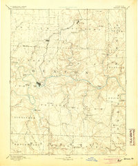
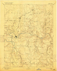
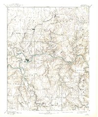
1894 Map of Warsaw
USGS Topo · Published 1894About this map
Warsaw sits at the vital confluence of the Grand River and the Osage River, serving as a central hub in this late 19th-century landscape. The Missouri Pacific Railroad cuts a narrow path through the northern territory, connecting the settlements of Lincoln and Cole Camp to the wider region. South of the river, the terrain is defined by the winding course of the Pomme De Terre River and smaller communities like Fairfield and Dell Delight. This survey reveals a time before massive reservoir projects altered the hydrology of central Missouri, showing the original river channels and named islands such as Wrights Island and Holloway Island. The map meticulously records numerous rural post offices and settlements, from Boylers Mills in the east to Quincy in the southwest, reflecting the distributed agrarian economy of the era.
Find a feature on this map
74 named features on this map. Tap any name to fly to it.
Don’t see what you’re looking for? This feature index may not catch every label — zoom into the map to look around manually.
Map Details
Editions of this 1894 Warsaw Map
4 editions found