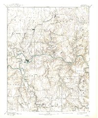
1894 Map of Warsaw
USGS Topo · Published 1938About this map
Warsaw serves as the focal point of this late 19th-century landscape, situated where the meandering Osage River meets the northern edge of the Ozark Plateau. The settlement pattern reveals a transition from the agricultural plains in the north, served by the Missouri Pacific Railroad through Lincoln and Cole Camp, to the more dissected river valleys of the south. This survey was conducted before the mid-20th-century dam projects, documenting the original course of the river and its many named islands, such as Wrights Island and Warsaw Island. For genealogists, the map identifies small, often vanished communities like Boeschenville, Palo Pinto, and Dell Delight. The topography illustrates the significant drainage systems of the Pomme de Terre River and Little Turkey Creek, providing a detailed look at the rural Missouri interior before modern inundations altered the landscape.
Find a feature on this map
59 named features on this map. Tap any name to fly to it.
Don’t see what you’re looking for? This feature index may not catch every label — zoom into the map to look around manually.
Map Details
Editions of this 1894 Warsaw Map
4 editions found

Other maps of this area

1884 · Bolivar
USGS Topo · 1:125,000

1885 · Warrensburg
USGS Topo · 1:125,000

1886 · Stockton
USGS Topo · 1:125,000

1887 · Clinton
USGS Topo · 1:125,000

1887 · Sedalia
USGS Topo · 1:125,000

1887 · Warsaw
USGS Topo · 1:125,000

1887 · Warrensburg
USGS Topo · 1:125,000

1888 · Versailles
USGS Topo · 1:125,000

1888 · Boonville
USGS Topo · 1:125,000

1892 · Bolivar
USGS Topo · 1:125,000