1887 Map of Warrensburg
USGS Topo · Published 1887About this map
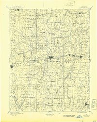
Warrensburg serves as the focal point of this Central Missouri landscape, situated along the primary line of the Missouri Pacific Railroad. Surveyed in 1885, the map reveals a highly structured township system where rural life was organized around small rail hubs like Knob Noster, Centerview, and Holden. The northern reach of the Kansas City and Southern Railroad clips the southwestern corner near Blair, while the local economy is punctuated by features like Carbon Hill and the Iron Spring south of the county seat. Numerous creeks, including Post Oak Creek and Black Jack Creek, create a dendritic drainage pattern across the prairie, influencing the location of early settlements like Fayetteville and Shawnee Mound. This record captures the region just as the expansion of the rail network solidified the dominance of these specific trade centers over earlier frontier outposts.
Find a feature on this map
53 named features on this map. Tap any name to fly to it.
Don’t see what you’re looking for? This feature index may not catch every label — zoom into the map to look around manually.
Map Details
Editions of this 1887 Warrensburg Map
This is the sole edition of this map. No revisions or reprints were ever made.
Historical Maps of Warrensburg Through Time
3 maps found