1887 Map of Warsaw
USGS Topo · Published 1887About this map
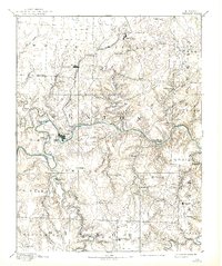
Warsaw serves as the focal point of this late 19th-century landscape, situated at a strategic bend where the Grand River meets the serpentine course of the Osage. The Missouri Pacific Railroad terminates here after winding southward through Lincoln, marking the town as a vital shipping hub before the era of major dam construction transformed the river valley. The surrounding terrain is a complex network of ridges and deep hollows, drained by a dense system of waterways including Tebo Creek, Knobby Creek, and the Little Pomme De Terre River. Small rural settlements like Fairfield, Dell Delight, and Cole Camp are scattered across the uplands, connected by early trails that follow the natural topography. This survey captures a moment when river islands like Warsaw Island and Holloway Island were prominent features of a free-flowing river system, long before the creation of modern reservoirs.
Find a feature on this map
65 named features on this map. Tap any name to fly to it.
Don’t see what you’re looking for? This feature index may not catch every label — zoom into the map to look around manually.
Map Details
Editions of this 1887 Warsaw Map
This is the sole edition of this map. No revisions or reprints were ever made.