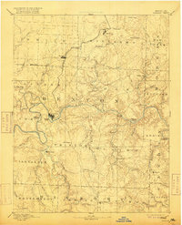
1894 Map of Warsaw
USGS Topo · Published 1916About this map
The Osage River dominates this 1885 survey of central Missouri, winding through a landscape of deep hollows and high ridges before the creation of modern reservoirs. The county seat of Warsaw serves as a focal point where the river meets a rugged interior populated by small nineteenth-century communities like Dell Delight, Palo Pinto, and Boeschenville. This reconnaissance mapping captures the region's early transport network, specifically the northern reach of the Missouri Pacific Railroad connecting Lincoln and Cole Camp.
Find a feature on this map
63 named features on this map. Tap any name to fly to it.
Don’t see what you’re looking for? This feature index may not catch every label — zoom into the map to look around manually.
Map Details
Editions of this 1894 Warsaw Map
4 editions found

Other maps of this area

1884 · Bolivar
USGS Topo · 1:125,000

1885 · Warrensburg
USGS Topo · 1:125,000

1886 · Stockton
USGS Topo · 1:125,000

1887 · Clinton
USGS Topo · 1:125,000

1887 · Sedalia
USGS Topo · 1:125,000

1887 · Warsaw
USGS Topo · 1:125,000

1887 · Warrensburg
USGS Topo · 1:125,000

1888 · Versailles
USGS Topo · 1:125,000

1888 · Boonville
USGS Topo · 1:125,000

1892 · Bolivar
USGS Topo · 1:125,000