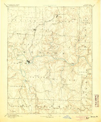
1894 Map of Warsaw
USGS Topo · Published 1904About this map
Warsaw serves as the hub of this late nineteenth-century landscape, positioned at the confluence of the Grand River and the Osage River. Long before the construction of modern dams and reservoirs, the region was defined by its intricate river systems and fertile valley floors. The Missouri Pacific Railroad snakes south from Cole Camp through Lincoln, providing a vital overland connection to the river commerce at Warsaw.
Find a feature on this map
71 named features on this map. Tap any name to fly to it.
Don’t see what you’re looking for? This feature index may not catch every label — zoom into the map to look around manually.
Map Details
Editions of this 1894 Warsaw Map
4 editions found

Other maps of this area

1884 · Bolivar
USGS Topo · 1:125,000

1885 · Warrensburg
USGS Topo · 1:125,000

1886 · Stockton
USGS Topo · 1:125,000

1887 · Clinton
USGS Topo · 1:125,000

1887 · Sedalia
USGS Topo · 1:125,000

1887 · Warsaw
USGS Topo · 1:125,000

1887 · Warrensburg
USGS Topo · 1:125,000

1888 · Versailles
USGS Topo · 1:125,000

1888 · Boonville
USGS Topo · 1:125,000

1892 · Bolivar
USGS Topo · 1:125,000