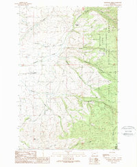
1989 Map of Grayhorse Creek
USGS Topo · Published 1989About this map
Threemile Creek and Ambrose Creek define the drainage patterns of this Bitterroot Valley landscape during the late 1980s. The agricultural character of the western flats is anchored by the Lone Rock School and its adjacent Athletic Field, where the Bitterroot Irrigation District Canal winds through the terrain to support local ranching. This waterway represents a vital piece of local infrastructure, marked by a Siphon as it crosses the valley floor.
Find a feature on this map
19 named features on this map. Tap any name to fly to it.
Don’t see what you’re looking for? This feature index may not catch every label — zoom into the map to look around manually.
Map Details
Editions of this 1989 Grayhorse Creek Map
This is the sole edition of this map. No revisions or reprints were ever made.
Other maps of this area

1901 · Hamilton
USGS Topo · 1:125,000

1903 · Bonner
USGS Topo · 1:125,000

1909 · Sapphire
USGS Topo · 1:125,000

1912 · Missoula
USGS Topo · 1:125,000

1947 · Butte
USGS Topo · 1:250,000

1956 · Hamilton
USGS Topo · 1:250,000

1958 · Butte
USGS Topo · 1:250,000

1959 · Hamilton
USGS Topo · 1:250,000

1959 · Cleveland Mountain
USGS Topo · 1:62,500

1960 · Butte
USGS Topo · 1:250,000