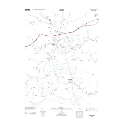
2013 Map of Grayson
USGS Topo · Published 2013About this map
Grayson serves as the central hub of this eastern Kentucky landscape, where the Little Sandy River winds through a terrain defined by deep hollows and named ridges. Local history is deeply embedded in the land, evidenced by the numerous family and community burial grounds such as Blankenship Cem, Edison Cem, and Goebel Cem that dot the hillsides. The survey details the convergence of smaller watercourses like Everman Cr and Barrett Cr as they feed into the main river system near Pactolus.
Find a feature on this map
239 named features on this map. Tap any name to fly to it.
Don’t see what you’re looking for? This feature index may not catch every label — zoom into the map to look around manually.
Map Details
Editions of this 2013 Grayson Map
This is the sole edition of this map. No revisions or reprints were ever made.
Other maps of this area

1903 · Kenova
USGS Topo · 1:125,000

1904 · Kenova
USGS Topo · 1:125,000

1950 · Bruin
USGS Topo · 1:24,000

1950 · Grahn
USGS Topo · 1:24,000

1950 · Tygarts Valley
USGS Topo · 1:24,000

1953 · Grayson
USGS Topo · 1:24,000

1953 · Oldtown
USGS Topo · 1:24,000

1953 · Rush
USGS Topo · 1:24,000
1953 · Argillite
USGS Topo · 1:24,000
1953 · Webbville
USGS Topo · 1:24,000