
1953 Map of Rush
USGS Topo · Published 1955About this map
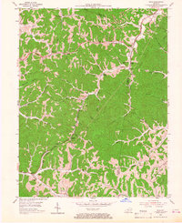
Industrial extraction and small hillside settlements define the landscape between Coalton and Denton in the early 1950s. The region is heavily marked by the Ashland Gas Field and numerous Strip Mines, which line the ridges and hollows. Transportation for these resources is anchored by the Chesapeake and Ohio railroad, which passes through Rush Station and Kilgore, paralleling the historic Midland Trail. Local life remains centered around a dense network of country schools and family landmarks, including Geigersville School, Star Schools, and the Wilson Creek Cemetery. The topography is a complex system of drainage, where Williams Creek and Upper Stinson Creek carve through the Boyd and Carter County line, reflecting a community deeply tied to both the land and its subsurface wealth.
Find a feature on this map
55 named features on this map. Tap any name to fly to it.
Don’t see what you’re looking for? This feature index may not catch every label — zoom into the map to look around manually.
Map Details
Editions of this 1953 Rush Map
2 editions found
Other maps of this area

1901 · Ceredo
USGS Topo · 1:62,500

1903 · Kenova
USGS Topo · 1:125,000

1904 · Kenova
USGS Topo · 1:125,000

1911 · Louisa
USGS Topo · 1:48,000

1913 · Ceredo
USGS Topo · 1:62,500

1913 · Louisa
USGS Topo · 1:62,500

1939 · Louisa
USGS Topo · 1:62,500

1953 · Grayson
USGS Topo · 1:24,000

1953 · Oldtown
USGS Topo · 1:24,000

1953 · Boltsfork
USGS Topo · 1:24,000