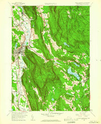
1958 Map of Great Barrington
USGS Topo · Published 1960About this map
Great Barrington sits as the central hub of this Berkshire County landscape, where the Housatonic River carves a fertile valley between prominent ridgelines. By the late 1950s, the area maintained a balance of industrial infrastructure and recreational space, evidenced by the New York New Haven and Hartford railroad line running parallel to the river and the Golf Course and Fairgrounds near the town center. The map reveals a high concentration of institutional and historical sites, including the Dehon Seminary, Elmwood Cem, and multiple schools like Brookside Sch.
Find a feature on this map
60 named features on this map. Tap any name to fly to it.
Don’t see what you’re looking for? This feature index may not catch every label — zoom into the map to look around manually.
Map Details
Editions of this 1958 Great Barrington Map
2 editions found
Other maps of this area

1885 · Sheffield
USGS Topo · 1:62,500

1886 · Becket
USGS Topo · 1:62,500

1888 · Sheffield
USGS Topo · 1:62,500

1888 · Becket
USGS Topo · 1:62,500

1888 · Sandisfield
USGS Topo · 1:62,500

1888 · Pittsfield
USGS Topo · 1:62,500

1890 · Pittsfield
USGS Topo · 1:62,500

1891 · Sheffield
USGS Topo · 1:62,500

1893 · Becket
USGS Topo · 1:62,500

1893 · Sheffield
USGS Topo · 1:62,500