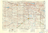
1955 Map of Great Bend
USGS Topo · Published 1973About this map
The Arkansas River and Smoky Hill River define the hydraulic landscape of central Kansas in this 1970 revision of the mid-century survey. Major water management projects and conservation areas are prominent, including the large Cheyenne Bottoms waterfowl refuge and the massive Quivira National Wildlife Refuge near Little Salt Marsh. The map documents a mature agricultural and industrial interior, where extensive Oil Fields punctuate the grid of section lines and county roads.
Find a feature on this map
170 named features on this map. Tap any name to fly to it.
Don’t see what you’re looking for? This feature index may not catch every label — zoom into the map to look around manually.
Map Details
Editions of this 1955 Great Bend Map
3 editions found

Other maps of this area

1889 · Cheney
USGS Topo · 1:125,000

1889 · Larned
USGS Topo · 1:125,000

1889 · Kinsley
USGS Topo · 1:125,000

1891 · Great Bend
USGS Topo · 1:125,000

1891 · Larned
USGS Topo · 1:125,000

1891 · Hutchinson
USGS Topo · 1:125,000

1891 · Cheney
USGS Topo · 1:125,000

1892 · Ness
USGS Topo · 1:125,000

1892 · Kinsley
USGS Topo · 1:125,000

1892 · Salina
USGS Topo · 1:125,000