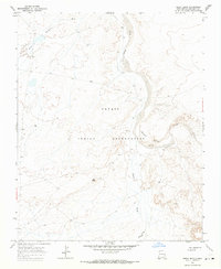
1966 Map of Great Bend
USGS Topo · Published 1969About this map
Navajo Indian Reservation lands dominate this mid-century survey of the high desert in San Juan County. The terrain is defined by the sweeping course of the Chaco River, which makes a significant turn at the namesake Great Bend. The landscape is a network of seasonal drainages including Sheep Springs Wash, Coyote Wash, and Salt Springs Wash, carving through the arid plateau. Human activity is sparsely marked by industrial and survival features, notably the Mines located near the base of Day Mesa. These scattered elements, including various wells and a remote drill hole, reflect a period of exploratory resource extraction and ranching in a region where water and mineral access were the primary drivers of movement and settlement.
Find a feature on this map
11 named features on this map. Tap any name to fly to it.
Don’t see what you’re looking for? This feature index may not catch every label — zoom into the map to look around manually.
Map Details
Editions of this 1966 Great Bend Map
This is the sole edition of this map. No revisions or reprints were ever made.
Other maps of this area

1889 · Chaco
USGS Topo · 1:250,000

1892 · Chaco
USGS Topo · 1:250,000

1927 · Sulphur Spring
USGS Topo · 1:96,000

1928 · Kirtland
USGS Topo · 1:125,000

1932 · Kirtland
USGS Topo · 1:125,000

1954 · Shiprock
USGS Topo · 1:250,000

1958 · Shiprock
USGS Topo · 1:250,000

1959 · Shiprock
USGS Topo · 1:250,000
1966 · Sheep Springs
USGS Topo · 1:24,000
1966 · Burnham Trading Post
USGS Topo · 1:24,000