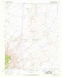
1966 Map of Sheep Springs
USGS Topo · Published 1969About this map
The Navajo Indian Reservation landscape in the mid-1960s is defined here by the drainage networks of the Tuntsa Wash and Sheep Springs Wash. At the center of the sheet, the north-south corridor of Route 666 serves as the primary artery connecting the small settlement of Sheep Springs to the surrounding high desert. To the northwest, the isolated label of Black House and the rising profile of Grey Mesa stand out against the arid terrain. The map records a snapshot of localized land use, including a Well and a Gravel Pit south of the main settlement, during a period when land lines had not yet been established across much of this territory.
Find a feature on this map
9 named features on this map. Tap any name to fly to it.
Don’t see what you’re looking for? This feature index may not catch every label — zoom into the map to look around manually.
Map Details
Editions of this 1966 Sheep Springs Map
2 editions found
Other maps of this area

1889 · Chaco
USGS Topo · 1:250,000

1892 · Chaco
USGS Topo · 1:250,000

1927 · Sulphur Spring
USGS Topo · 1:96,000

1928 · Kirtland
USGS Topo · 1:125,000

1932 · Kirtland
USGS Topo · 1:125,000

1953 · Sanostee
USGS Topo · 1:62,500

1954 · Shiprock
USGS Topo · 1:250,000

1958 · Shiprock
USGS Topo · 1:250,000

1959 · Shiprock
USGS Topo · 1:250,000
1966 · Tsin-nas-kid
USGS Topo · 1:24,000