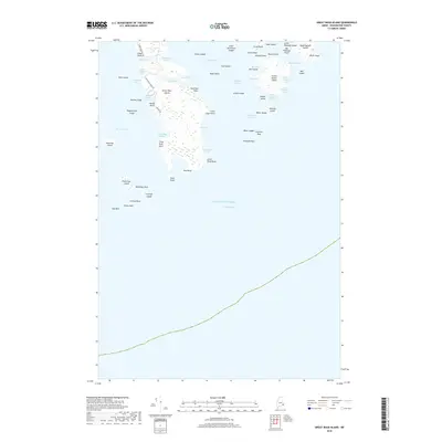
2018 Map of Great Wass Island
USGS Topo · Published 2018About this map
Great Wass Island and its surrounding archipelago dominate this coastal Maine survey, revealing a landscape defined by intricate coves and granite ledges. Modern access is traced via Station Rd and Black Duck Cove Rd, leading toward the southern reaches of the island. The map details the remote character of the shoreline, from the sheltered Three Falls Harbor to the exposed Popplestone Cove. To the east, larger landmasses like Head Harbor Island and Steele Harbor Island shield the inner waters of Mistake Harbor. The presence of Mannings Farm near the southwestern shore provides a rare point of named agricultural settlement amidst the marshes and rocky points. This record is particularly useful for maritime historians and genealogists studying the Downeast coast, as it meticulously labels smaller features like Money Island, Mistake Island, and the treacherous Popplestone Ledge.
Find a feature on this map
66 named features on this map. Tap any name to fly to it.
Don’t see what you’re looking for? This feature index may not catch every label — zoom into the map to look around manually.
Map Details
Editions of this 2018 Great Wass Island Map
This is the sole edition of this map. No revisions or reprints were ever made.
Other maps of this area

1918 · Machias
USGS Topo · 1:62,500

1921 · Great Wass Island
USGS Topo · 1:62,500

1921 · Columbia Falls
USGS Topo · 1:62,500

1941 · Columbia Falls
USGS Topo · 1:62,500

1941 · Machias
USGS Topo · 1:62,500

1942 · Columbia Falls
USGS Topo · 1:62,500

1948 · Jonesport
USGS Topo · 1:24,000

1948 · Roque Bluffs
USGS Topo · 1:24,000

1948 · Drisko Island
USGS Topo · 1:24,000
1948 · Addison
USGS Topo · 1:24,000