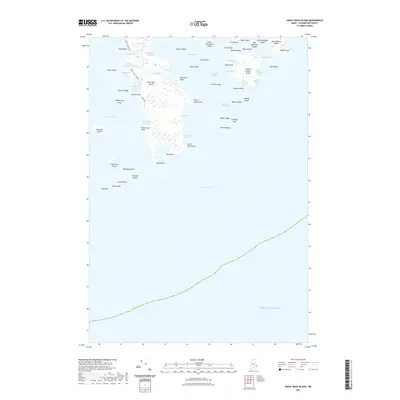
2021 Map of Great Wass Island
USGS Topo · Published 2021About this map
Great Wass Island and the surrounding archipelago of Washington County anchor this maritime survey, showcasing a complex coastline of inlets and harbors. To the north and east, substantial landmasses like Head Harbor Island and Big Peabody Island create protected waters such as Mistake Harbor and Head Harbor. The presence of Mannings Farm on the southern tip of the main island provides a rare terrestrial landmark among the numerous coves and ledges. Small thoroughfares and inlets, including Three Falls Harbor and Black Duck Cove, suggest a landscape historically defined by coastal navigation. Land-based infrastructure is minimal, represented by a few local routes like Station Rd and Black Duck Cove Rd that navigate the island's interior and shoreline. Outlying features like Mistake Island and Money Island mark the transition into the Atlantic Ocean.
Find a feature on this map
65 named features on this map. Tap any name to fly to it.
Don’t see what you’re looking for? This feature index may not catch every label — zoom into the map to look around manually.
Map Details
Editions of this 2021 Great Wass Island Map
This is the sole edition of this map. No revisions or reprints were ever made.
Other maps of this area

1918 · Machias
USGS Topo · 1:62,500

1921 · Great Wass Island
USGS Topo · 1:62,500

1921 · Columbia Falls
USGS Topo · 1:62,500

1941 · Columbia Falls
USGS Topo · 1:62,500

1941 · Machias
USGS Topo · 1:62,500

1942 · Columbia Falls
USGS Topo · 1:62,500

1948 · Jonesport
USGS Topo · 1:24,000

1948 · Roque Bluffs
USGS Topo · 1:24,000

1948 · Drisko Island
USGS Topo · 1:24,000
1948 · Addison
USGS Topo · 1:24,000