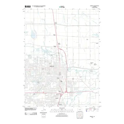
2010 Map of Greeley
USGS Topo · Published 2010About this map
The Cache la Poudre River and South Platte River define the hydraulic landscape of this Weld County hub, where an intricate network of irrigation systems including the Ogilvy Ditch, Latham Ditch, and the Greeley Number 3 Ditch supports the region's agricultural legacy. This 2010 survey illustrates the expansion of Greeley as it surrounds the University of Northern Colorado and integrates neighboring communities like Garden City and Rosedale. The map provides significant detail for genealogists, marking the Linn Grove Cemetery, Evans Cemetery, and Sunset Memorial Cemetery. Regional infrastructure is well-documented, from the Greeley-Weld County Airport in the east to the Greeley Mall retail corridor. Small settlements and crossroads such as Lucerne, Mason Corner, and Mumper Corner persist along the northern periphery, while the southern edge transition into Evans, showing the continued urban densification along the river valleys.
Find a feature on this map
55 named features on this map. Tap any name to fly to it.
Don’t see what you’re looking for? This feature index may not catch every label — zoom into the map to look around manually.
Map Details
Editions of this 2010 Greeley Map
This is the sole edition of this map. No revisions or reprints were ever made.
Other maps of this area

1902 · Greeley
USGS Topo · 1:125,000

1908 · Eaton
USGS Topo · 1:125,000

1910 · Eaton
USGS Topo · 1:125,000

1950 · Greeley
USGS Topo · 1:24,000

1950 · Kersey
USGS Topo · 1:24,000

1950 · Bracewell
USGS Topo · 1:24,000

1950 · Milliken
USGS Topo · 1:24,000

1950 · Valley View School
USGS Topo · 1:24,000

1950 · La Salle
USGS Topo · 1:24,000
1951 · Milliken
USGS Topo · 1:24,000