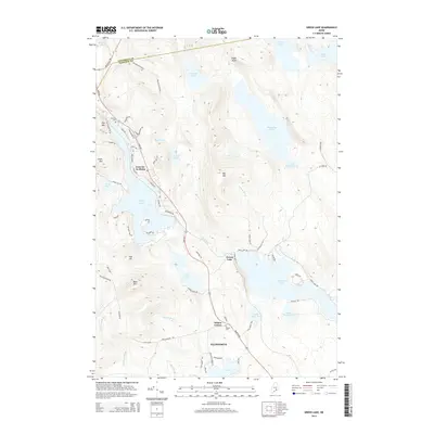
2014 Map of Green Lake
USGS Topo · Published 2014About this map
Lucerne-in-Maine serves as a primary residential hub in this corner of Hancock County, situated along the western shores of Phillips Lake. The landscape is defined by its dramatic relief, where Eagle Bluff and Big Hill overlook a dense network of glacial ponds and interconnecting waterways. Further south, Wilson Corner marks a critical junction within the town of Ellsworth, where the terrain transitions toward the sprawling expanse of Green Lake. Genealogy researchers will find interest in the documented locations of Eastern Cem and Wilson Cem, providing specific spatial context for local families. The map also delineates the Penobscot and Hancock county line, highlighting the administrative boundaries that intersect this lake-studded region. Significant water bodies like Hatcase Pond and Mountainy Pond dominate the northern section, illustrating the complex drainage patterns of Mann Brook and Jellison Brook.
Find a feature on this map
79 named features on this map. Tap any name to fly to it.
Don’t see what you’re looking for? This feature index may not catch every label — zoom into the map to look around manually.
Map Details
Editions of this 2014 Green Lake Map
This is the sole edition of this map. No revisions or reprints were ever made.
Other maps of this area

1900 · Orland
USGS Topo · 1:62,500

1902 · Orono
USGS Topo · 1:62,500

1911 · Ellsworth
USGS Topo · 1:62,500

1929 · Great Pond
USGS Topo · 1:48,000

1932 · Great Pond
USGS Topo · 1:62,500

1940 · Ellsworth
USGS Topo · 1:62,500

1942 · Orland
USGS Topo · 1:62,500

1942 · Ellsworth
USGS Topo · 1:62,500

1944 · Orono
USGS Topo · 1:62,500

1946 · Orono
USGS Topo · 1:62,500