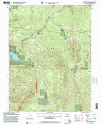
1994 Map of Green Mountain
USGS Topo · Published 2001About this map
Pike National Forest dominates this mountain landscape, providing a detailed record of the high-elevation terrain between Buffalo Creek and the Lost Creek Wilderness. Revised in the mid-1990s, the map highlights the recreational and natural intersections of the Front Range, specifically following the winding path of the Colorado Trail as it traverses the western slopes of Green Mountain. Water resources and drainage patterns are central to the topography, defined by the Wellington Lake reservoir and the complex network of gulches including Buck Gulch and Miller Gulch. Small clearings and settlements like Webster Park and the Meadows Group appear alongside mountain landmarks such as Redskin Mountain and Baldy Peak, documenting the transition from managed forest lands to protected wilderness areas.
Find a feature on this map
27 named features on this map. Tap any name to fly to it.
Don’t see what you’re looking for? This feature index may not catch every label — zoom into the map to look around manually.
Map Details
Editions of this 1994 Green Mountain Map
2 editions found
Other maps of this area

1893 · Platte Canyon
USGS Topo · 1:125,000

1945 · Platte Canyon
USGS Topo · 1:24,000

1945 · Pine
USGS Topo · 1:24,000

1945 · Bailey
USGS Topo · 1:24,000

1948 · Pine
USGS Topo · 1:24,000

1948 · Platte Canyon
USGS Topo · 1:24,000

1949 · Bailey
USGS Topo · 1:24,000

1953 · Denver
USGS Topo · 1:250,000

1954 · Deckers
USGS Topo · 1:24,000

1954 · Green Mountain
USGS Topo · 1:24,000