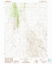
1990 Map of Green Springs SW
USGS Topo · Published 1990About this map
The high desert basins and ranges of central Nevada meet at the boundary of White Pine and Nye counties in this 1990 survey. The topography is dominated by the north-south alignment of the Pancake Range and the Duckwater Hills, which separate the expansive Railroad Valley from Duckwater Valley. This landscape reflects the classic basin and range structure of the region, where wide alluvial valleys are bounded by steep, isolated mountain blocks.
Find a feature on this map
8 named features on this map. Tap any name to fly to it.
Don’t see what you’re looking for? This feature index may not catch every label — zoom into the map to look around manually.
Map Details
Editions of this 1990 Green Springs SW Map
This is the sole edition of this map. No revisions or reprints were ever made.
Other maps of this area

1951 · Green Springs
USGS Topo · 1:62,500

1956 · Lund
USGS Topo · 1:250,000

1956 · Ely
USGS Topo · 1:250,000

1959 · Ely
USGS Topo · 1:250,000

1960 · Lund
USGS Topo · 1:250,000

1963 · Ely
USGS Topo · 1:250,000

1964 · Duckwater
USGS Topo · 1:62,500

1964 · Moody Peak
USGS Topo · 1:62,500

1968 · Brown Summit
USGS Topo · 1:24,000

1979 · Mt. Hamilton
USGS Topo · 1:100,000