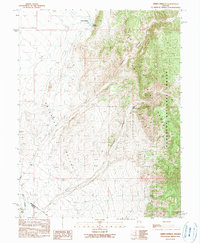
1990 Map of Green Springs
USGS Topo · Published 1990About this map
Railroad Valley meets the rising slopes of the White Pine Range in this late twentieth-century survey of the Nevada interior. The landscape is defined by the transition from arid lowlands to the protected high ground of the Humboldt National Forest. Life in this environment centers on water management, evidenced by the Diversion Ditch cutting across the valley floor to channel resources toward the Green Springs (Corral). The placement of the Green Springs and nearby Birch Spring highlights the critical importance of natural water sources for ranching and livestock in this high-desert territory. Topographic details trace the sharp descent of Lampson Canyon and Freeland Canyon, while the southern boundary marks the divide between White Pine and Nye counties.
Find a feature on this map
12 named features on this map. Tap any name to fly to it.
Don’t see what you’re looking for? This feature index may not catch every label — zoom into the map to look around manually.
Map Details
Editions of this 1990 Green Springs Map
This is the sole edition of this map. No revisions or reprints were ever made.
Other maps of this area

1949 · Treasure Hill
USGS Topo · 1:62,500

1950 · Treasure Hill
USGS Topo · 1:62,500

1951 · Green Springs
USGS Topo · 1:62,500

1956 · Lund
USGS Topo · 1:250,000

1956 · Ely
USGS Topo · 1:250,000

1957 · Currant Mtn
USGS Topo · 1:62,500

1959 · Ely
USGS Topo · 1:250,000

1960 · Lund
USGS Topo · 1:250,000

1963 · Ely
USGS Topo · 1:250,000

1964 · Duckwater
USGS Topo · 1:62,500