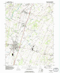
1990 Map of Greencastle
USGS Topo · Published 1995About this map
Greencastle serves as the central hub of this Franklin County landscape, showing a well-established network of residential streets, schools, and civic infrastructure in the 1990s. The town’s history is anchored by landmarks like the Greencastle-Antrim High Sch and multiple houses of worship, including Bethany Ch. Surrounding the borough, the rural character of Antrim and Guilford townships is defined by scattered hamlets like Shady Grove and Kauffman, alongside a legacy of industry represented by the Browns Mill and various extraction sites such as the Slate Pit and Gravel Pit.
Find a feature on this map
61 named features on this map. Tap any name to fly to it.
Don’t see what you’re looking for? This feature index may not catch every label — zoom into the map to look around manually.
Map Details
Editions of this 1990 Greencastle Map
This is the sole edition of this map. No revisions or reprints were ever made.
Other maps of this area

1900 · Mercersburg
USGS Topo · 1:62,500

1902 · Chambersburg
USGS Topo · 1:62,500

1902 · Mercersburg
USGS Topo · 1:62,500

1909 · Hagerstown
USGS Topo · 1:48,000

1912 · Hagerstown
USGS Topo · 1:62,500

1912 · Williamsport
USGS Topo · 1:62,500

1942 · Hagerstown
USGS Topo · 1:125,000

1943 · Hagerstown
USGS Topo · 1:125,000

1943 · Chambersburg
USGS Topo · 1:62,500

1943 · Mercersburg
USGS Topo · 1:62,500