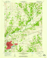
1958 Map of Greencastle
USGS Topo · Published 1959About this map
The university town of Greencastle serves as a major railway junction in the late 1950s, where the Pennsylvania, Monon, and New York Central lines converge. The campus of De Pauw Univ is clearly delineated near the town center, including the university Observatory and Administration Bldg. Beyond the urban core, the landscape is defined by the winding course of Big Walnut Creek and its many crossings, including the Covered Bridge and Pinhook Bridge.
Find a feature on this map
63 named features on this map. Tap any name to fly to it.
Don’t see what you’re looking for? This feature index may not catch every label — zoom into the map to look around manually.
Map Details
Editions of this 1958 Greencastle Map
This is the sole edition of this map. No revisions or reprints were ever made.
Other maps of this area

1951 · Clinton Falls
USGS Topo · 1:24,000

1952 · Reelsville
USGS Topo · 1:24,000

1953 · Indianapolis
USGS Topo · 1:250,000

1955 · Russellville
USGS Topo · 1:24,000

1956 · Indianapolis
USGS Topo · 1:250,000

1956 · Cloverdale
USGS Topo · 1:24,000

1956 · Eminence
USGS Topo · 1:24,000

1957 · Indianapolis
USGS Topo · 1:250,000

1958 · Roachdale
USGS Topo · 1:24,000

1958 · Coatesville
USGS Topo · 1:24,000