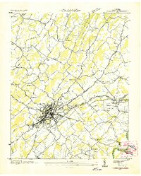
1936 Map of Greeneville
USGS Topo · Published 1936About this map
Greeneville serves as the focal point of this 1936 survey, showing the town's dense street grid and rail connections during the era of New Deal expansion. The map captures a moment of significant federal presence, notably the Andrew Johnson National Cem and the CCC Camp No 4492 located just east of the city center. The landscape is characterized by a network of rural schools and family-named landmarks like Hardin Chapel and Gass Bridge Sch, illustrating the dispersed settlement patterns of Greene County. To the east, Tusculum and Tusculum College are clearly defined along the Andrew Johnson Highway. Along the southern edge, the Nolichucky River meanders near industrial and utility markers including a Flume Mill and Pumping Sta, while the Southern Railway provides the primary industrial artery through the valley.
Find a feature on this map
49 named features on this map. Tap any name to fly to it.
Don’t see what you’re looking for? This feature index may not catch every label — zoom into the map to look around manually.
Map Details
Editions of this 1936 Greeneville Map
This is the sole edition of this map. No revisions or reprints were ever made.
Other maps of this area

1892 · Greeneville
USGS Topo · 1:125,000

1896 · Greeneville
USGS Topo · 1:125,000

1904 · Greeneville
USGS Topo · 1:125,000

1935 · Surgoinsville
USGS Topo · 1:48,000

1935 · Baileyton
USGS Topo · 1:24,000

1935 · McCloud
USGS Topo · 1:24,000

1935 · Mosheim
USGS Topo · 1:24,000

1935 · Cedar Creek
USGS Topo · 1:24,000

1935 · Fall Branch
USGS Topo · 1:48,000
1935 · Jearoldstown
USGS Topo · 1:24,000