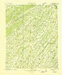
1935 Map of Fall Branch
USGS Topo · Published 1935About this map
Goshen Mountain and Bays Mountain form a rugged backdrop for this 1935 Tennessee Valley Authority survey, which documents the complex rural landscape at the intersection of Washington, Sullivan, Hawkins, and Greene Counties. The region is defined by a dense network of mountain ridges like Chimney Top Mountain and fertile valleys where agriculture and early industry thrived. Fall Branch and Sullivan Gardens serve as primary hubs, connected by a web of early state routes including State Hwy No 81.
Find a feature on this map
69 named features on this map. Tap any name to fly to it.
Don’t see what you’re looking for? This feature index may not catch every label — zoom into the map to look around manually.
Map Details
Editions of this 1935 Fall Branch Map
This is the sole edition of this map. No revisions or reprints were ever made.
Other maps of this area

1891 · Roan Mountain
USGS Topo · 1:125,000

1892 · Greeneville
USGS Topo · 1:125,000

1894 · Roan Mountain
USGS Topo · 1:125,000

1894 · Estillville
USGS Topo · 1:125,000

1896 · Greeneville
USGS Topo · 1:125,000

1897 · Bristol
USGS Topo · 1:125,000

1902 · Bristol
USGS Topo · 1:125,000

1904 · Roan Mountain
USGS Topo · 1:125,000

1904 · Greeneville
USGS Topo · 1:125,000
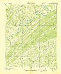
1935 · Surgoinsville
USGS Topo · 1:48,000