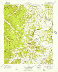
1951 Map of Greenfield Bend
USGS Topo · Published 1957About this map
The Duck River winds through a landscape of deep hollows and sharp ridges at the intersection of Hickman, Maury, and Lewis Counties. This era of Tennessee history is marked by a transition from traditional river-bound commerce to modern roadway access, as seen where the Natchez Trace and Mc Cord Highway cut across the high ground of Nine Mile Ridge. Settlement is clustered around the post office at Shady Grove Duck River and the industrial remnants at Kettle Mills. Local life is anchored by family-named landmarks like Delk Island and dozens of country cemeteries, including the Gordon Ferry Church Cem. Of particular interest to local historians is the Forty Thicket School (Abandoned), which stands as a silent witness to a changing educational system, while the Weatherly Lookout Tower provides a structural reference point for forest management in the mid-century.
Find a feature on this map
120 named features on this map. Tap any name to fly to it.
Don’t see what you’re looking for? This feature index may not catch every label — zoom into the map to look around manually.
Map Details
Editions of this 1951 Greenfield Bend Map
3 editions found
Other maps of this area

1901 · Colombia
USGS Topo · 1:125,000

1936 · Williamsport
USGS Topo · 1:24,000

1936 · Primm
USGS Topo · 1:24,000

1936 · Mt Joy
USGS Topo · 1:24,000

1936 · Nunnelly
USGS Topo · 1:24,000

1936 · Sunrise
USGS Topo · 1:24,000

1936 · Littlelot
USGS Topo · 1:24,000

1936 · Greenfield Bend
USGS Topo · 1:24,000

1936 · Mount Pleasant
USGS Topo · 1:24,000

1936 · Gordonsburg
USGS Topo · 1:24,000