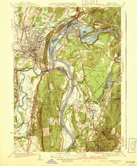
1941 Map of Greenfield
USGS Topo · Published 1941About this map
The confluence of the Connecticut River and the Deerfield River dictates the development of this 1930s-era landscape, where rail and road infrastructure tightly follow the winding watercourses. Three major rail lines, including the Boston and Maine RR and Central Vermont RR, converge to serve industrial centers like Greenfield and Turners Falls. The map reveals a high density of civic and educational institutions, most notably Deerfield Academy and Stoneleigh Prospect Hill Sch, alongside localized services like the Great River Sch.
Find a feature on this map
83 named features on this map. Tap any name to fly to it.
Don’t see what you’re looking for? This feature index may not catch every label — zoom into the map to look around manually.
Map Details
Editions of this 1941 Greenfield Map
3 editions found
Other maps of this area

1885 · Northampton
USGS Topo · 1:62,500

1886 · Northampton
USGS Topo · 1:62,500

1887 · Warwick
USGS Topo · 1:62,500

1887 · Belchertown
USGS Topo · 1:62,500

1889 · Warwick
USGS Topo · 1:62,500

1890 · Belchertown
USGS Topo · 1:62,500

1890 · Greenfield
USGS Topo · 1:62,500

1891 · Northampton
USGS Topo · 1:62,500

1893 · Northampton
USGS Topo · 1:62,500

1893 · Belchertown
USGS Topo · 1:62,500