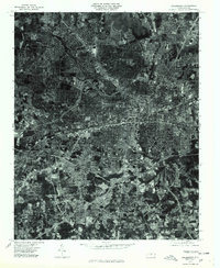
1977 Map of Greensboro
USGS Topo · Published 1979About this map
Greensboro and its expanding residential and commercial footprints are captured in this orthophotograph based on 1977 aerial imagery. The sheet illustrates the suburban development of the era, showcasing the distinct layouts of neighborhoods such as Fairfield and Edgeville to the north and east. To the west, the winding streets of Hamilton Lakes stand in contrast to the more linear industrial and transportation corridors nearby. The drainage of South Buffalo Creek provides a natural landmark through the southern half of the map, passing near several outlying communities. Local historians can observe the density of the urban core compared to established peripheral areas like Sedge-Town, Pinecroft, and Vandalia. This visual record serves as a precise documentation of the city's infrastructure and land use during the late 1970s, just before further modern expansion altered these established boundaries.
Find a feature on this map
8 named features on this map. Tap any name to fly to it.
Don’t see what you’re looking for? This feature index may not catch every label — zoom into the map to look around manually.
Map Details
Editions of this 1977 Greensboro Map
This is the sole edition of this map. No revisions or reprints were ever made.
Other maps of this area

1950 · High Point East
USGS Topo · 1:24,000

1951 · High Point East
USGS Topo · 1:24,000

1951 · Guilford
USGS Topo · 1:24,000

1951 · Lake Brandt
USGS Topo · 1:24,000

1951 · Browns Summit
USGS Topo · 1:24,000

1951 · Greensboro
USGS Topo · 1:24,000

1952 · Mc Leansville
USGS Topo · 1:24,000

1953 · Raleigh
USGS Topo · 1:250,000

1953 · Greensboro
USGS Topo · 1:250,000

1954 · Greensboro
USGS Topo · 1:250,000
Featured Places
- Greensboro, NC
- Sedgefield Park, NC
- Starmount Forest, Greensboro
- Meadowood Homes, Greensboro
- Friendly Acres, Greensboro