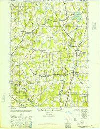
1946 Map of Greenville
USGS Topo · Published 1946About this map
Greenville and South Westerlo anchor this mid-century portrait of the upper Hudson Valley borderlands between Albany and Greene Counties. The landscape is defined by the hydraulic infrastructure of the Basic Reservoir and its associated Filtration Plant, which manage the flow of Basic Creek through the rural townships. The settlement pattern is traditional and dispersed, marked by family-named crossroads like Smith Corner, Lambs Corner, and O'Hara Corners. Several rural schools, including School No 3 and School No 5, remain visible alongside numerous burial grounds such as Westerlo Central Cem and Craw Cem. The southwestern corner of the sheet transitions into the Helderberg foothills, where Catskill Creek and Thorp Creek converge near Norton Hill, illustrating the transition from agricultural plateaus to the more dissected terrain of the Catskill fringe.
Find a feature on this map
28 named features on this map. Tap any name to fly to it.
Don’t see what you’re looking for? This feature index may not catch every label — zoom into the map to look around manually.
Map Details
Editions of this 1946 Greenville Map
This is the sole edition of this map. No revisions or reprints were ever made.
Other maps of this area

1893 · Coxsackie
USGS Topo · 1:62,500

1893 · Durham
USGS Topo · 1:62,500

1893 · Albany
USGS Topo · 1:62,500

1894 · Coxsackie
USGS Topo · 1:62,500

1894 · Durham
USGS Topo · 1:62,500

1895 · Albany
USGS Topo · 1:62,500

1898 · Albany
USGS Topo · 1:62,500

1900 · Berne
USGS Topo · 1:62,500

1903 · Berne
USGS Topo · 1:62,500

1927 · Albany
USGS Topo · 1:62,500