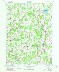
1980 Map of Greenville
USGS Topo · Published 1981About this map
The rolling hills of the Albany and Greene County borderland are defined here by a network of creeks and small hamlets. Basic Creek Reservoir dominates the northeastern corner, feeding into Basic Creek as it winds southward toward Greenville. This 1980 update, based on earlier Army Map Service work, illustrates a landscape where traditional agricultural settlements like South Westerlo, Norton Hill, and Smith Corner persist alongside mid-century additions such as the Drive-in Theater and the Greenville-Rainbow Airport. Genealogists will find a wealth of local burial sites, including Westerlo Central Cem, Locust Cem, and the family-named Campbell Cem. To the south, the terrain descends toward the banks of Catskill Creek, where historical features like the Stone Bridge Cem sit near the confluence of Thorp Creek.
Find a feature on this map
29 named features on this map. Tap any name to fly to it.
Don’t see what you’re looking for? This feature index may not catch every label — zoom into the map to look around manually.
Map Details
Editions of this 1980 Greenville Map
This is the sole edition of this map. No revisions or reprints were ever made.
Other maps of this area

1893 · Coxsackie
USGS Topo · 1:62,500

1893 · Durham
USGS Topo · 1:62,500

1893 · Albany
USGS Topo · 1:62,500

1894 · Coxsackie
USGS Topo · 1:62,500

1894 · Durham
USGS Topo · 1:62,500

1895 · Albany
USGS Topo · 1:62,500

1898 · Albany
USGS Topo · 1:62,500

1900 · Berne
USGS Topo · 1:62,500

1903 · Berne
USGS Topo · 1:62,500

1927 · Albany
USGS Topo · 1:62,500