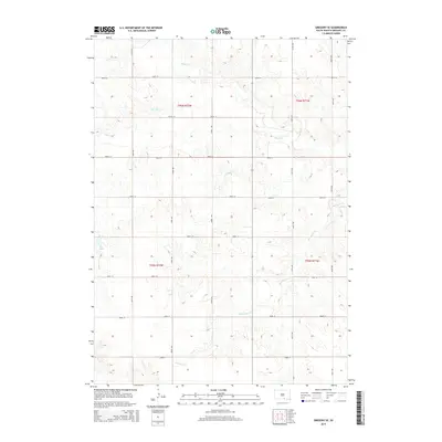
2015 Map of Gregory SE
USGS Topo · Published 2015About this map
Ponca Cr and Murphy Cr drain the rolling plains of southern South Dakota in this 2015 U.S. Geological Survey representation of Gregory County. The landscape is defined by the Public Land Survey System's rigid grid, where roads like 296th St and 341st Ave follow township lines through t96n r72w and t95n r71w. This section of the Milk's Camp Segment reveals a highly organized agricultural and range environment, punctuated by water features such as Star Lake and the winding course of Blue Eyes Cr. The map captures the enduring rural character of the Great Plains, illustrating how the late-nineteenth-century township-and-range survey continues to dictate modern infrastructure and movement across the land.
Find a feature on this map
21 named features on this map. Tap any name to fly to it.
Don’t see what you’re looking for? This feature index may not catch every label — zoom into the map to look around manually.
Map Details
Editions of this 2015 Gregory SE Map
This is the sole edition of this map. No revisions or reprints were ever made.
Other maps of this area

1955 · Mitchell
USGS Topo · 1:250,000

1955 · O'Neill
USGS Topo · 1:250,000

1959 · O'Neill
USGS Topo · 1:250,000

1959 · Mitchell
USGS Topo · 1:250,000

1964 · Gregory SE
USGS Topo · 1:24,000

1964 · Herrick NW
USGS Topo · 1:24,000

1964 · Mills
USGS Topo · 1:24,000

1964 · Gregory
USGS Topo · 1:24,000
1964 · Herrick
USGS Topo · 1:24,000
1964 · Carlock
USGS Topo · 1:24,000