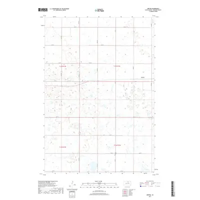
2017 Map of Gretna
USGS Topo · Published 2017About this map
Gretna and the surrounding agricultural landscape of Edmunds County are defined by the rigid grid of the Public Land Survey System, as seen in this 2017 study. The settlement itself sits along a primary east-west corridor, surrounded by a dense network of sectional roads such as 334th Ave and 134th St. This area of the Great Plains is characterized by numerous small prairie potholes and wetlands that dot the fields between farmsteads. A significant local landmark for genealogists is the Cloyd Valley Cem, located south of the main settlement near Co Rd 3. The map illustrates the persistence of early land divisions and the rural infrastructure required to support the region's farming economy, with routes like Co Rd 4A connecting remote acreage to local hubs.
Find a feature on this map
21 named features on this map. Tap any name to fly to it.
Don’t see what you’re looking for? This feature index may not catch every label — zoom into the map to look around manually.
Map Details
Editions of this 2017 Gretna Map
This is the sole edition of this map. No revisions or reprints were ever made.
Other maps of this area
1954 · Aberdeen
USGS Topo · 1:250,000
1956 · Aberdeen
USGS Topo · 1:250,000
1974 · Gretna
USGS Topo · 1:24,000
1974 · Bowdle SE
USGS Topo · 1:24,000
1974 · Roscoe SW
USGS Topo · 1:24,000
1974 · Bowdle
USGS Topo · 1:24,000
1978 · Hillsview SE
USGS Topo · 1:24,000
1978 · Roscoe NW
USGS Topo · 1:24,000
1978 · Bowdle SW
USGS Topo · 1:24,000
1978 · Bowdle-Hosmer Lake
USGS Topo · 1:24,000