
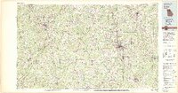
1979 Map of Griffin
USGS Topo · Published 1980This historical map portrays the area of Griffin in 1979, primarily covering Spalding County as well as portions of Clayton County, Henry County, Heard County, Coweta County, Monroe County, Upson County, Carroll County, Fayette County, Newton County, Butts County, Meriwether County, Troup County, Pike County, and Lamar County. Featuring a scale of 1:100000, this map provides a highly detailed snapshot of the terrain, roads, buildings, counties, and historical landmarks in the Griffin region at the time. Published in 1980, it is one of 3 known editions of this map due to revisions or reprints.
Find a feature on this map
92 named features on this map. Tap any name to fly to it.
Don’t see what you’re looking for? This feature index may not catch every label — zoom into the map to look around manually.
Map Details
Editions of this 1979 Griffin Map
3 editions found
Historical Maps of Newnan Pines Through Time
1 maps found