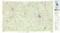
1979 Map of Griffin
USGS Topo · Published 1980About this map
The Flint River and Chattahoochee River carve through the Piedmont landscape of west-central Georgia, framing a region defined by its historic railroad towns and emerging suburban growth. In this late 1970s landscape, the city of Griffin serves as a major hub, flanked by the agricultural and research center of Experiment and the industrial corridors of the Southern Railway and Central of Georgia Railroad. To the northwest, the planned development of Peachtree City and the seat of Newnan show the westward expansion of the metropolitan reach.
Find a feature on this map
92 named features on this map. Tap any name to fly to it.
Don’t see what you’re looking for? This feature index may not catch every label — zoom into the map to look around manually.
Map Details
Editions of this 1979 Griffin Map
3 editions found
Other maps of this area

1888 · Atlanta
USGS Topo · 1:125,000

1889 · Tallapoosa
USGS Topo · 1:125,000

1890 · Atlanta
USGS Topo · 1:125,000

1891 · Marietta
USGS Topo · 1:125,000

1892 · Tallapoosa
USGS Topo · 1:125,000

1892 · Atlanta
USGS Topo · 1:125,000

1895 · Atlanta
USGS Topo · 1:125,000

1895 · Marietta
USGS Topo · 1:125,000

1896 · Monroe
USGS Topo · 1:125,000

1897 · Marietta
USGS Topo · 1:125,000