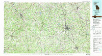
1979 Map of Griffin
USGS Topo · Published 1980About this map
The Flint River and Chattahoochee River define the drainage of this central Georgia landscape during the late 1970s, as the region experienced significant growth between major municipalities. Griffin serves as a primary hub for the Central of Georgia and Southern railroads, while Peachtree City and Newnan show the northward expansion toward the metropolitan fringe. The presence of the Atlanta International Raceway near Hampton and the State Experimental Farm at Experiment highlight the mix of modern recreational development and established agricultural research defining the era.
Find a feature on this map
116 named features on this map. Tap any name to fly to it.
Don’t see what you’re looking for? This feature index may not catch every label — zoom into the map to look around manually.
Map Details
Editions of this 1979 Griffin Map
3 editions found

Historical Maps of Newnan Through Time
1 maps found