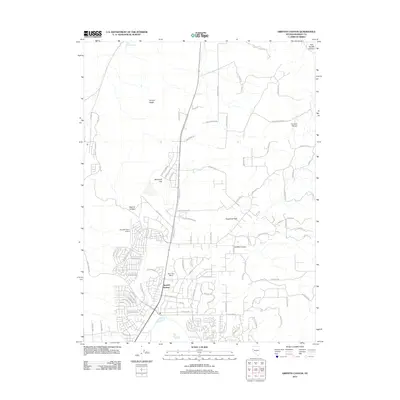
2011 Map of Griffith Canyon
USGS Topo · Published 2011About this map
Spanish Springs and the nearby Reno Sky Ranch anchor this landscape during a period of significant suburban expansion northeast of the Reno-Sparks area. The grid of residential streets, including Bartmess Blvd and Neighborhood Way, pushes into the high desert basin, contrasting sharply with the undeveloped terrain of the Curnow Range and Hungry Ridge to the north.
Find a feature on this map
96 named features on this map. Tap any name to fly to it.
Don’t see what you’re looking for? This feature index may not catch every label — zoom into the map to look around manually.
Map Details
Editions of this 2011 Griffith Canyon Map
This is the sole edition of this map. No revisions or reprints were ever made.
Other maps of this area

1891 · Reno
USGS Topo · 1:125,000

1893 · Reno
USGS Topo · 1:125,000

1950 · Reno
USGS Topo · 1:62,500

1951 · Reno
USGS Topo · 1:62,500

1957 · Sutcliffe
USGS Topo · 1:62,500
1957 · Vista
USGS Topo · 1:24,000

1957 · Dogskin Mountain
USGS Topo · 1:62,500

1957 · Spanish Springs Valley
USGS Topo · 1:62,500

1957 · Reno
USGS Topo · 1:250,000

1959 · Reno
USGS Topo · 1:250,000