
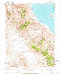
1957 Map of Sutcliffe
USGS Topo · Published 1959About this map
Sutcliffe sits on the western shore of Pyramid Lake, serving as a focal point within the Pyramid Lake Indian Reservation in the late 1950s. The landscape is defined by the sharp transition from the deep water of the lake to the high desert peaks of the Pah Rah Range and Dogskin Mountain. Infrastructure of the era is represented by the Southern Pacific railroad line skirting the shoreline, providing a vital link through this arid corridor.
Find a feature on this map
50 named features on this map. Tap any name to fly to it.
Don’t see what you’re looking for? This feature index may not catch every label — zoom into the map to look around manually.
Map Details
Editions of this 1957 Sutcliffe Map
2 editions found
Other maps of this area

1886 · Granite Range
USGS Topo · 1:250,000

1890 · Wadsworth
USGS Topo · 1:125,000

1891 · Reno
USGS Topo · 1:125,000

1892 · Wadsworth
USGS Topo · 1:125,000

1893 · Reno
USGS Topo · 1:125,000

1894 · Granite Range
USGS Topo · 1:250,000

1894 · Wadsworth
USGS Topo · 1:125,000

1950 · Reno
USGS Topo · 1:62,500

1951 · Reno
USGS Topo · 1:62,500

1955 · Lovelock
USGS Topo · 1:250,000