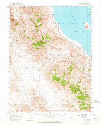
1957 Map of Sutcliffe
USGS Topo · Published 1964About this map
Pyramid Lake dominates the eastern half of this Nevada landscape, its shores defining the boundary of the Pyramid Lake Indian Reservation. The small settlement of Sutcliffe sits along the western shoreline, serving as a focal point near the Anaho Island National Wildlife Refuge, which protects the prominent Anaho Island and the smaller Pyramid Island. To the west, the Virginia Mountains rise sharply, characterized by high points like Tule Peak and geological features such as Needle Rock.
Find a feature on this map
35 named features on this map. Tap any name to fly to it.
Don’t see what you’re looking for? This feature index may not catch every label — zoom into the map to look around manually.
Map Details
Editions of this 1957 Sutcliffe Map
2 editions found

Other maps of this area

1886 · Granite Range
USGS Topo · 1:250,000

1890 · Wadsworth
USGS Topo · 1:125,000

1891 · Reno
USGS Topo · 1:125,000

1892 · Wadsworth
USGS Topo · 1:125,000

1893 · Reno
USGS Topo · 1:125,000

1894 · Granite Range
USGS Topo · 1:250,000

1894 · Wadsworth
USGS Topo · 1:125,000

1950 · Reno
USGS Topo · 1:62,500

1951 · Reno
USGS Topo · 1:62,500

1955 · Lovelock
USGS Topo · 1:250,000