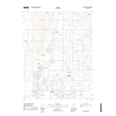
2018 Map of Griffith Canyon
USGS Topo · Published 2018About this map
Spanish Springs and the northern reaches of Sparks dominate this 2018 survey of the Nevada high desert. The transition from the dense residential street networks of the south to the open, arid basins of Spanish Springs Valley is stark, illustrating the rapid outward growth of these communities. Infrastructure like the Spanish Springs Airport and the corridor of Co HWY 202 anchors the local economy, while the surrounding landscape is defined by stark geological features. The Curnow Range and Junction House Range flank the valley, creating a natural amphitheater for landmarks such as Sugarloaf Peak and Hungry Ridge. Water remains a vital, albeit rare, resource in this environment, evidenced by isolated features like Little Hungry Spring and the drainage of Stormy Canyon. Local place names like Bacon Rind Flat and Boneyard Flat add unique regional character to the desert floor.
Find a feature on this map
174 named features on this map. Tap any name to fly to it.
Don’t see what you’re looking for? This feature index may not catch every label — zoom into the map to look around manually.
Map Details
Editions of this 2018 Griffith Canyon Map
This is the sole edition of this map. No revisions or reprints were ever made.
Other maps of this area

1891 · Reno
USGS Topo · 1:125,000

1893 · Reno
USGS Topo · 1:125,000

1950 · Reno
USGS Topo · 1:62,500

1951 · Reno
USGS Topo · 1:62,500

1957 · Sutcliffe
USGS Topo · 1:62,500
1957 · Vista
USGS Topo · 1:24,000

1957 · Dogskin Mountain
USGS Topo · 1:62,500

1957 · Spanish Springs Valley
USGS Topo · 1:62,500

1957 · Reno
USGS Topo · 1:250,000

1959 · Reno
USGS Topo · 1:250,000