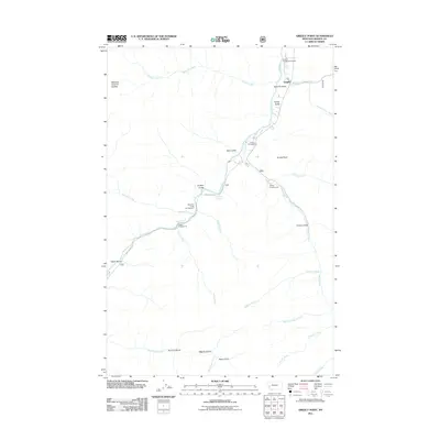
2011 Map of Grizzly Point
USGS Topo · Published 2011About this map
Quigley serves as a lone settlement point in this 2011 survey of the Granite County landscape, where steep drainages and mountain hydrology dictate the human footprint. The area is defined by the convergence of numerous waterways, most notably Rock Creek, which is flanked by the winding Rock Creek Rd and several public recreation sites including Norton Campground and Dalles Campground. The topography is etched with numerous named gulches such as Hamm Gulch, Waho Gulch, and Colusa Gulch, revealing a system of ravines that feed into the larger creek basins. High points like Grizzly Point and Welcome Sawmill Saddle offer navigational orientation for those tracing the backcountry of the Lolo and Helena-Lewis and Clark National Forest areas. Outdoor access is prioritized through features like the Sawmill Sportsmans Access, highlighting the region's enduring role as a destination for fishing and mountain transit.
Find a feature on this map
33 named features on this map. Tap any name to fly to it.
Don’t see what you’re looking for? This feature index may not catch every label — zoom into the map to look around manually.
Map Details
Editions of this 2011 Grizzly Point Map
This is the sole edition of this map. No revisions or reprints were ever made.
Other maps of this area

1903 · Bonner
USGS Topo · 1:125,000

1909 · Sapphire
USGS Topo · 1:125,000

1947 · Butte
USGS Topo · 1:250,000

1958 · Butte
USGS Topo · 1:250,000

1959 · Cleveland Mountain
USGS Topo · 1:62,500

1959 · Ravenna
USGS Topo · 1:62,500

1960 · Butte
USGS Topo · 1:250,000

1962 · Butte
USGS Topo · 1:250,000
1974 · Sawmill Saddle
USGS Topo · 1:24,000
1975 · Alder Gulch
USGS Topo · 1:24,000