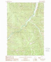
1989 Map of Grizzly Point
USGS Topo · Published 1989About this map
Rock Creek flows through the center of this terrain, dividing the Welcome Creek Wilderness to the west from the expansive Lolo National Forest to the east. The landscape is defined by its drainage network, with numerous gulches and creeks such as Sawmill Creek, Welcome Creek, and Elkhorn Creek feeding into the main valley. The map documents a specific recreational and historical geography, noting established sites like Norton Campground and Grizzly Campground, alongside the historical location of Quigley (Site) and the small settlement of Brewster. Human activity is primarily limited to the road corridor along the river and various trails, including a notable Footbridge crossing, reflecting a moment when this part of Granite County remained largely dedicated to timber and wilderness management.
Find a feature on this map
31 named features on this map. Tap any name to fly to it.
Don’t see what you’re looking for? This feature index may not catch every label — zoom into the map to look around manually.
Map Details
Editions of this 1989 Grizzly Point Map
This is the sole edition of this map. No revisions or reprints were ever made.
Other maps of this area

1903 · Bonner
USGS Topo · 1:125,000

1909 · Sapphire
USGS Topo · 1:125,000

1947 · Butte
USGS Topo · 1:250,000

1958 · Butte
USGS Topo · 1:250,000

1959 · Cleveland Mountain
USGS Topo · 1:62,500

1959 · Ravenna
USGS Topo · 1:62,500

1960 · Butte
USGS Topo · 1:250,000

1962 · Butte
USGS Topo · 1:250,000
1974 · Sawmill Saddle
USGS Topo · 1:24,000
1975 · Alder Gulch
USGS Topo · 1:24,000