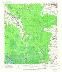
1962 Map of Grosse Tete
USGS Topo · Published 1968About this map
Bayou Grosse Tete and the Intracoastal Waterway define the hydraulic landscape of this region during the early 1960s, where the natural watercourses of the Atchafalaya Basin meet industrial infrastructure. Significant agricultural heritage is evident in the presence of Myrtle Grove Plantation, Star Plantation, and Enterprise Plantation, marking the enduring influence of the plantation economy on the Iberville Parish landscape. The settlement patterns follow the ridges and rails, with Rosedale and Grosse Tete serving as key nodes along the Texas and Pacific railroad line.
Find a feature on this map
70 named features on this map. Tap any name to fly to it.
Don’t see what you’re looking for? This feature index may not catch every label — zoom into the map to look around manually.
Map Details
Editions of this 1962 Grosse Tete Map
2 editions found
Other maps of this area

1906 · Bayou Sara
USGS Topo · 1:125,000

1908 · Baton Rouge
USGS Topo · 1:62,500

1935 · Osca Bayou
USGS Topo · 1:62,500

1935 · Chicot Lake
USGS Topo · 1:62,500

1936 · White Castle
USGS Topo · 1:62,500

1939 · Zachary
USGS Topo · 1:62,500

1939 · Baton Rouge
USGS Topo · 1:62,500

1939 · Fordoche
USGS Topo · 1:62,500

1940 · Grosse Tete
USGS Topo · 1:62,500

1941 · Loreauville
USGS Topo · 1:62,500