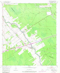
1954 Map of Grosse Tete
USGS Topo · Published 1980About this map
Bayou Grosse Tete snakes through the heart of this Iberville Parish landscape, serving as a historic corridor for both water and rail transportation. The Texas and Pacific railroad follows the high ground of the levee system, anchoring the linear settlements of Rosedale and Grosse Tete. These communities emerged along the fertile banks where the bayou provided essential drainage and transport. The map reveals a transition from these established town sites into the surrounding wetlands, marked by a dense network of canals, ditches, and spoil banks.
Find a feature on this map
32 named features on this map. Tap any name to fly to it.
Don’t see what you’re looking for? This feature index may not catch every label — zoom into the map to look around manually.
Map Details
Editions of this 1954 Grosse Tete Map
4 editions found

Other maps of this area

1906 · Bayou Sara
USGS Topo · 1:125,000

1935 · Osca Bayou
USGS Topo · 1:62,500

1939 · Fordoche
USGS Topo · 1:62,500

1940 · Grosse Tete
USGS Topo · 1:62,500

1953 · Cow Bayou
USGS Topo · 1:24,000

1953 · Lobdell
USGS Topo · 1:24,000

1953 · Maringouin
USGS Topo · 1:24,000

1953 · Addis
USGS Topo · 1:24,000

1953 · Grosse Tete SW
USGS Topo · 1:24,000

1954 · Walls
USGS Topo · 1:24,000