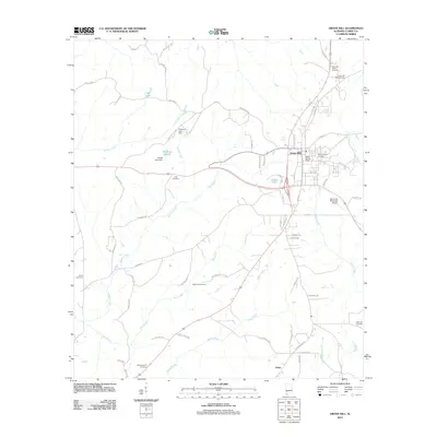
2011 Map of Grove Hill
USGS Topo · Published 2011About this map
Grove Hill serves as the central hub of this Alabama landscape, where the local government and commerce intersect along corridors like Court St and N Church St. The town's layout reflects a traditional Southern county seat, with the Grove Hill Post Office and Wilson Chapel Cemetery situated near the heart of the community. Beyond the residential grid, the terrain is defined by a dense network of watercourses including Tattilaba Creek, Rabbit Creek, and Mill Creek, which carve through the surrounding timberlands.
Find a feature on this map
67 named features on this map. Tap any name to fly to it.
Don’t see what you’re looking for? This feature index may not catch every label — zoom into the map to look around manually.
Map Details
Editions of this 2011 Grove Hill Map
This is the sole edition of this map. No revisions or reprints were ever made.
Other maps of this area

1953 · Andalusia
USGS Topo · 1:250,000

1957 · Andalusia
USGS Topo · 1:250,000

1972 · Whatley
USGS Topo · 1:24,000

1972 · Suggsville
USGS Topo · 1:24,000

1973 · Fulton East
USGS Topo · 1:24,000

1978 · Jackson
USGS Topo · 1:24,000

1978 · McEntyre
USGS Topo · 1:24,000

1978 · Winn
USGS Topo · 1:24,000
1978 · Grove Hill
USGS Topo · 1:24,000
1978 · Fulton West
USGS Topo · 1:24,000