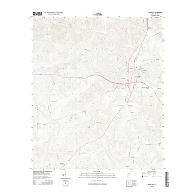
2014 Map of Grove Hill
USGS Topo · Published 2014About this map
Grove Hill serves as the central hub of this Clarke County landscape, where the town's street grid transitions into a network of creeks and rural family cemeteries. Genealogists will find a wealth of records in the distribution of burial grounds, including the large Magnolia Lawns Cem to the north and the smaller Pugh Cem and Smith Cem scattered across the western woodlands. The area's water system is defined by Tattilaba Cr and Jackson Cr, which feed several small reservoirs like Pugh Lake and Burge Lake. Transportation is anchored by the Grove Hill Municipal Airport on the eastern edge of town, while historical routes like Old Saint Stephens Rd hint at the region's earlier development patterns. To the south, the small settlement of Union sits near Simmons Cr, marking the lower extent of this documented area.
Find a feature on this map
83 named features on this map. Tap any name to fly to it.
Don’t see what you’re looking for? This feature index may not catch every label — zoom into the map to look around manually.
Map Details
Editions of this 2014 Grove Hill Map
This is the sole edition of this map. No revisions or reprints were ever made.
Other maps of this area

1953 · Andalusia
USGS Topo · 1:250,000

1957 · Andalusia
USGS Topo · 1:250,000

1972 · Whatley
USGS Topo · 1:24,000

1972 · Suggsville
USGS Topo · 1:24,000

1973 · Fulton East
USGS Topo · 1:24,000

1978 · Jackson
USGS Topo · 1:24,000

1978 · McEntyre
USGS Topo · 1:24,000

1978 · Winn
USGS Topo · 1:24,000
1978 · Grove Hill
USGS Topo · 1:24,000
1978 · Fulton West
USGS Topo · 1:24,000