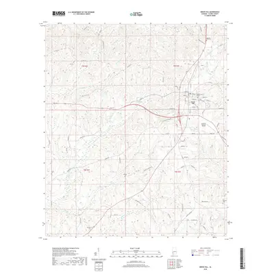
2018 Map of Grove Hill
USGS Topo · Published 2018About this map
The town of Grove Hill serves as the focal point of this Clarke County landscape, situated where several local routes and residential streets like Dubose Ave and Callier St converge. The area is dense with family history markers, featuring numerous burial grounds such as Magnolia Lawns Cem, Wilson Chapel Cem, and Hollingsworth Cem scattered through the surrounding countryside. Outside the town center, the terrain is defined by a network of waterways including Tattilaba Cr and Jackson Cr, alongside smaller bodies like Pugh Lake and Gillis Lake.
Find a feature on this map
87 named features on this map. Tap any name to fly to it.
Don’t see what you’re looking for? This feature index may not catch every label — zoom into the map to look around manually.
Map Details
Editions of this 2018 Grove Hill Map
This is the sole edition of this map. No revisions or reprints were ever made.
Other maps of this area

1953 · Andalusia
USGS Topo · 1:250,000

1957 · Andalusia
USGS Topo · 1:250,000

1972 · Whatley
USGS Topo · 1:24,000

1972 · Suggsville
USGS Topo · 1:24,000

1973 · Fulton East
USGS Topo · 1:24,000

1978 · Jackson
USGS Topo · 1:24,000

1978 · McEntyre
USGS Topo · 1:24,000

1978 · Winn
USGS Topo · 1:24,000
1978 · Grove Hill
USGS Topo · 1:24,000
1978 · Fulton West
USGS Topo · 1:24,000