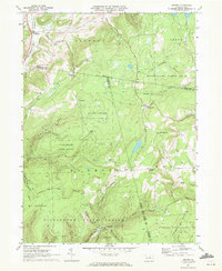
1969 Map of Grover
USGS Topo · Published 1972About this map
Canton Mountain and the deep valleys of the Endless Mountains define the character of this 1969 landscape, where industrial remnants and remote settlements occupy the rugged terrain of northern Pennsylvania. The northern reaches are centered on Grover, a primary rail point along the Penn Central tracks following the course of Towanda Creek. Further south, the map reveals a transition toward vast public lands including the Tiadaghton State Forest and State Game Lands No 12. Evidence of earlier resource extraction and transit is found in the Old Railroad Grade near Masten and the various jeep trails that crisscross the steep ridges. Small rural communities like Wheelerville and Ellenton appear alongside local landmarks such as Parsons Hill Ch and the Schoolhouse Hollow drainage, reflecting a settlement pattern that adapted to the narrow valleys and upland plateaus between Rock Run and Schrader Creek.
Find a feature on this map
56 named features on this map. Tap any name to fly to it.
Don’t see what you’re looking for? This feature index may not catch every label — zoom into the map to look around manually.
Map Details
Editions of this 1969 Grover Map
This is the sole edition of this map. No revisions or reprints were ever made.
Other maps of this area

1927 · Eagles Mere
USGS Topo · 1:48,000

1930 · Warrensville
USGS Topo · 1:62,500

1932 · Eagle Mere
USGS Topo · 1:62,500

1934 · Warrensville
USGS Topo · 1:62,500

1942 · Canton
USGS Topo · 1:62,500

1943 · Powell
USGS Topo · 1:62,500

1944 · Canton
USGS Topo · 1:62,500

1945 · Powell
USGS Topo · 1:62,500

1953 · Warrensville
USGS Topo · 1:62,500

1953 · Eagles Mere
USGS Topo · 1:62,500
Featured Places
- Leroy Township, PA
- Union Township, PA
- Maple Summit, Fox Township
- Canton Township, PA
- Wheelerville, Fox Township