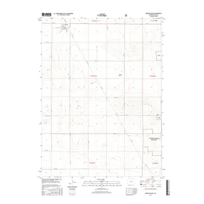
2016 Map of Grover South
USGS Topo · Published 2016About this map
The small town of Grover sits at the northern edge of this high plains landscape, where the grid of the town site meets the vast open spaces of the Pawnee National Grassland. The map reveals a highly structured environment defined by section lines and an extensive county road network, including Co Rd 110 and Co Rd 390, which serve the local ranching and agricultural community. The drainage of Jackson Draw provides a subtle topographic break in the terrain, suggesting the ephemeral water patterns critical to this arid region.
Find a feature on this map
32 named features on this map. Tap any name to fly to it.
Don’t see what you’re looking for? This feature index may not catch every label — zoom into the map to look around manually.
Map Details
Editions of this 2016 Grover South Map
This is the sole edition of this map. No revisions or reprints were ever made.
Other maps of this area
1954 · Greeley
USGS Topo · 1:250,000
1957 · Greeley
USGS Topo · 1:250,000
1958 · Greeley
USGS Topo · 1:250,000
1961 · Greeley
USGS Topo · 1:250,000
1964 · Greeley
USGS Topo · 1:250,000
1965 · Greeley
USGS Topo · 1:250,000
1972 · Grover North
USGS Topo · 1:24,000
1972 · Briggsdale
USGS Topo · 1:24,000
1972 · Keota NW
USGS Topo · 1:24,000
1972 · Hereford
USGS Topo · 1:24,000