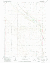
1972 Map of Hereford
USGS Topo · Published 1974About this map
Hereford sits as the central point of activity in this 1970s landscape, positioned where the Burlington Northern railroad tracks cross the high plains of northern Weld County. The settlement patterns here are defined by the path of Crow Creek, which winds southeast through a terrain dotted with numerous Well and Wells sites. These features, along with a Pipeline and a Pumping Sta, highlight the infrastructure necessary for managing water and energy in this arid ranching environment just south of the Wyoming border. The map also documents property boundaries with fine red dashed lines indicating selected fence lines, providing a detailed look at land division during this era of field checking by the U.S. Geological Survey.
Find a feature on this map
8 named features on this map. Tap any name to fly to it.
Don’t see what you’re looking for? This feature index may not catch every label — zoom into the map to look around manually.
Map Details
Editions of this 1972 Hereford Map
2 editions found
Other maps of this area

1954 · Cheyenne
USGS Topo · 1:250,000

1954 · Greeley
USGS Topo · 1:250,000

1957 · Greeley
USGS Topo · 1:250,000

1958 · Cheyenne
USGS Topo · 1:250,000

1958 · Greeley
USGS Topo · 1:250,000

1961 · Greeley
USGS Topo · 1:250,000

1963 · Arcola
USGS Topo · 1:24,000

1963 · Carpenter
USGS Topo · 1:24,000

1963 · Pine Bluffs SW
USGS Topo · 1:24,000

1964 · Greeley
USGS Topo · 1:250,000