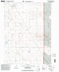
1997 Map of Grover South
USGS Topo · Published 2000About this map
Grover serves as the primary hub on this northeastern Colorado prairie, reflecting a landscape shaped by both traditional ranching and the energy industry. The town's local life is centered around the High School and the Rodeo Ground, while the broader terrain reveals the extensive reach of the Keota Oil Field, marked by a network of pipelines and Oil Tanks. To the east, the Pawnee National Grassland encompasses a significant portion of the high plains, where landmarks like the Sligo Cemetery and the Big Divide Windmill provide specific points of reference for genealogists and local historians. The drainage of Jackson Draw and Crow Creek cut through the topography, illustrating the vital role of water management in this arid environment, further evidenced by numerous labeled wells and water tanks across the sections.
Find a feature on this map
14 named features on this map. Tap any name to fly to it.
Don’t see what you’re looking for? This feature index may not catch every label — zoom into the map to look around manually.
Map Details
Editions of this 1997 Grover South Map
This is the sole edition of this map. No revisions or reprints were ever made.
Other maps of this area

1954 · Greeley
USGS Topo · 1:250,000

1957 · Greeley
USGS Topo · 1:250,000

1958 · Greeley
USGS Topo · 1:250,000

1961 · Greeley
USGS Topo · 1:250,000

1964 · Greeley
USGS Topo · 1:250,000

1965 · Greeley
USGS Topo · 1:250,000
1972 · Grover North
USGS Topo · 1:24,000

1972 · Briggsdale
USGS Topo · 1:24,000

1972 · Keota NW
USGS Topo · 1:24,000
1972 · Hereford
USGS Topo · 1:24,000