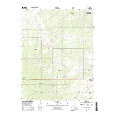
2017 Map of Grover
USGS Topo · Published 2017About this map
Grover sits at the northern edge of this high-altitude landscape, where local roads like Center ST and State Rte 12 connect the settlement to the surrounding wilderness. The terrain is defined by dramatic transitions, from the high plateaus of Boulder Mtn and The Terrace in the southwest to the deep incisions of Nixon Canyon and Capitol Wash in the east. This survey captures the boundary between Dixie National Forest and Capitol Reef National Park, illustrating a region where water management is critical, as seen at the Wide Hollow Reservoir and along Sulphur Cr in Happy Valley. Notable landmarks like The Three Brothers and Devils Slide provide clear orientation points for those navigating the backcountry. Genealogists will find the Grover Cem at the foot of the mountains, while the network of mountain roads such as Miner's Mountain Rd reflects the long history of livestock and resource access in Wayne County.
Find a feature on this map
44 named features on this map. Tap any name to fly to it.
Don’t see what you’re looking for? This feature index may not catch every label — zoom into the map to look around manually.
Map Details
Editions of this 2017 Grover Map
This is the sole edition of this map. No revisions or reprints were ever made.
Other maps of this area

1885 · Fish Lake
USGS Topo · 1:250,000

1896 · Fish Lake
USGS Topo · 1:250,000

1952 · Notom 3 SW
USGS Topo · 1:24,000

1952 · Notom 3 NW
USGS Topo · 1:24,000

1952 · Notom 2 SE
USGS Topo · 1:24,000

1952 · Notom 2 SW
USGS Topo · 1:24,000

1952 · Notom 4 NW
USGS Topo · 1:24,000

1952 · Notom 4 SW
USGS Topo · 1:24,000

1952 · Notom 3 SE
USGS Topo · 1:24,000

1952 · Notom 3 NE
USGS Topo · 1:24,000